About Avia Maps Aeronautical Charts
The reliable and straightforward aviation maps for pilots and aerospace enthusiasts around the world. The app is suited for pre-flight planning as well as in-flight navigation. Simply choose any 5 by 5 degree area on...
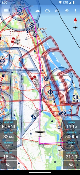
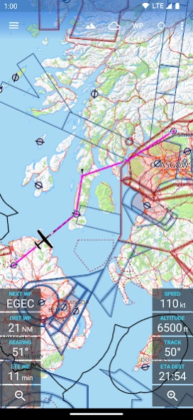
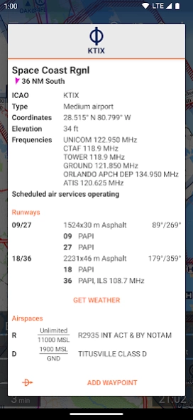
The reliable and straightforward aviation maps for pilots and aerospace enthusiasts around the world. The app is suited for pre-flight planning as well as in-flight navigation. Simply choose any 5 by 5 degree area on earth and download relevant data for offline use. The map features over 65000 airports, 9000 navaids and 15000 waypoints around the globe, just as airspaces for currently 62 countries on all continents (except Antarctica). Countries with airspace data include the United States and Canada, Europe, Australia and New Zealand.
Global, high resolution weather forecasts from the German DWD and US American NOAA provide accurate map layers for cloud cover, ceiling, precipitation, wind on the ground as well as aloft. The data is downloaded onto the device, so you can check the forecast even during flight without cell reception. To retrieve the latest METAR and TAF at your destination airport it is integrated with Avia Weather.
A digital elevation model supports you with planning your route in the mountains. During flight the terrain overlay will dynamically color hills and mountains on the map depending on your current altitude to increase your situational awareness.
To enhance safety, Avia Maps can display traffic information from your favorite ADS-B receiver or from the SafeSky app directly on the map. It supports receiving traffic data using the GDL90 format, which is supported by most portable ADS-B receivers like SkyEcho or Stratux. If you do not have a receiver, SafeSky can provide traffic data using an internet connection only.
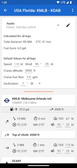
For the most accurate performance calculations you can create multiple aircraft profiles from handbook values for climb performance, fuel consumption etc. Route calculations will use these profiles and even consider engine type and fuel burn for climb performance, employing common formulae used in aerospace engineering. From as little as four carefully chosen data points the app can accurately recreate the climb performance diagram in your POH.
For clarity and commonality to paper charts the map is themed in the style of ICAO Annex 4 (Aeronautical Charts). If you use the app on multiple devices you can synchronize your routes, aircraft profiles and user waypoints between them.
This is a trial app with full features. After an evaluation period of 30 days you will have to buy a perpetual license from within the app or subscribe to the professional tier.
Previous Versions
Here you can find the changelog of Avia Maps Aeronautical Charts since it was posted on our website on 2016-10-07 09:18:36.
The latest version is 3.12.1 and it was updated on 2024-04-01 09:45:45. See below the changes in each version.
Avia Maps Aeronautical Charts version 3.12.1
Updated At: 2024-03-13
Changes: Bugfix: Tiles without any aviation data (e.g. in the middle of the ocean) could not be removed from the device.
Minor bugfixes and performance improvements.
Avia Maps Aeronautical Charts version 3.11.7
Updated At: 2024-01-14
Changes: Minor bugfixes and compatibility with Android 14.
Avia Maps Aeronautical Charts version 3.11.6
Updated At: 2023-10-23
Changes: Bugfix: Airspaces were not drawn on Android 7 and older.
Minor bugfixes and compatibility with Android 14.
Avia Maps Aeronautical Charts version 3.11.5
Updated At: 2023-10-23
Changes: Change: Updated French translation.
Bugfix and Performance: Changes in the map engine to reduce memory pressure and avoid OOM errors.
Minor bugfixes and compatibility with Android 14.
Avia Maps Aeronautical Charts version 3.11.3
Updated At: 2023-10-04
Changes: NEW: Traffic overlay. The app can now receive and display GDL90 traffic data from Safe Sky and compatible ADS-B receivers.
Change: Updated Czech translation.
Bugfix: Handle aircraft models without mass variation between climb rate fulcrums.
Bugfix: Preparation for zoom level 14 base map update to keep file sizes below 4GB.
Avia Maps Aeronautical Charts version 3.11.1
Updated At: 2023-07-06
Changes: NEW: Traffic overlay. The app can now receive and display GDL90 traffic data from Safe Sky and compatible ADS-B receivers.
Avia Maps Aeronautical Charts version 3.10.8
Updated At: 2023-06-27
Changes: NEW: Colored terrain overlay depending on your current or manually selected altitude. After the download the app will first have to prepare the overlay once, which is a long running task. Available on Android 7+.
Change: The zoom buttons are now larger and moved from the toolbar to the bottom of the screen.
Change: Previously the .gpx route import was limited to 100 waypoints. Now tracks with more points can also be imported but are smoothed.
Several minor bugfixes.
Avia Maps Aeronautical Charts version 3.9.2
Updated At: 2023-03-26
Changes: Bugfix: Fixed error which crashed the app when starting downloads in case the permission to show a download progress notification was never granted.
Minor bugfixes.
Avia Maps Aeronautical Charts version
Updated At: 2022-04-20
Changes: NEW: Navaid idents and names of smaller airports are now drawn on the map.
Bugfix: Fixed a bug which may have caused the app to crash when attempting to automatically resolve a sync conflict.
Bugfix: Crash caused by invalid characters in user waypoint names.
Minor bugfixes.
Avia Maps Aeronautical Charts version
Updated At: 2021-12-08
Changes: NEW: Synchronization for routes, aircraft models and user waypoints.
NEW: Import user waypoint names from GPX and FPL files.
NEW: Support for Android 12
Bugfix: Fixed a bug where waypoint names would not disappear when closing a route.
Bugfix: Incorrect GPX route import.
Completely reworked route storage to integrate sync and fixed several minor bugs in the process.
Improved map rendering performance.
Disclaimer
Official Google Play Link
We do not host Avia Maps Aeronautical Charts on our servers. We did not scan it for viruses, adware, spyware or other type of malware. This app is hosted by Google and passed their terms and conditions to be listed there. We recommend caution when installing it.
The Google Play link for Avia Maps Aeronautical Charts is provided to you by apps112.com without any warranties, representations or guarantees of any kind, so access it at your own risk.
If you have questions regarding this particular app contact the publisher directly. For questions about the functionalities of apps112.com contact us.